Earthquake Details
Paphos, Cyprus 4.9m Earthquake, Tuesday Apr. 26 2022, 10:11:33 PM
Paphos, Cyprus Earthquake
The USGS has reported a 4.9 magnitude earthquake has struck 2 km SSW of Paphos, Cyprus on Apr. 26 2022, 10:11:33 PM, at a depth of 10 km. There were no significant injuries or damage reported at this point, Friendly Forecast will update this report as events unfold.
Fore and Aftershocks
There has been other seismic activity around the 4.9 Paphos, Cyprus earthquake. Below you will find the fore and after shocks associated with it.
| Quake Type | Magnitude | Location | Time | Date |
|---|---|---|---|---|
| Aftershock | 4.2 | 2 km ESE of Konia, Cyprus | 11:02:20 PM | Apr. 26 2022 |
Did you feel it?
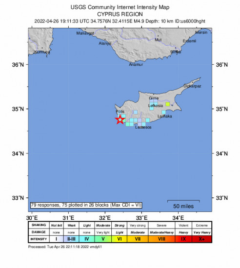
79 others have felt the Paphos, Cyprus earthquake and have since reported it. See below for the response locations and intensities.
 Community Internet Intensity Map
| Responses | Location | Shaking | Distance |
|---|---|---|---|
| 1 | Avdimou, Avdimou, Government controlled area, Cyprus | LIGHT | 34 km |
| 5 | Chlorakas, Chlorakas, Government controlled area, Cyprus | LIGHT | 11 km |
| 3 | Empa, Empa, Government controlled area, Cyprus | LIGHT | 11 km |
| 1 | Ergates, Ergates, Government controlled area, Cyprus | LIGHT | 83 km |
| 1 | Kissonerga, Kissonerga, Government controlled area, Cyprus | WEAK | 12 km |
| 6 | Koloni, Koloni, Government controlled area, Cyprus | LIGHT | 11 km |
| 2 | Konia, Konia, Government controlled area, Cyprus | MODERATE | 11 km |
| 2 | Kouklia, Kouklia, Government controlled area, Cyprus | LIGHT | 19 km |
| 1 | Larnaca, Larnaca, Government controlled area, Cyprus | LIGHT | 113 km |
| 1 | Lemesos, Lemesos, Government controlled area, Cyprus | LIGHT | 59 km |
| 1 | Lempa, Lempa, Government controlled area, Cyprus | LIGHT | 11 km |
| 1 | Mesogi, Mesogi, Government controlled area, Cyprus | LIGHT | 12 km |
| 2 | Mouttagiaka, Mouttagiaka, Government controlled area, Cyprus | LIGHT | 63 km |
| 5 | Nicosia, Nicosia, Government controlled area, Cyprus | LIGHT | 99 km |
| 1 | Pachna, Pachna, Government controlled area, Cyprus | LIGHT | 37 km |
| 16 | Pafos, Pafos, Government controlled area, Cyprus | LIGHT | 10 km |
| 1 | Pano Akourdaleia, Pano Akourdaleia, Government controlled area, Cyprus | WEAK | 22 km |
| 1 | Pano Platres, Pano Platres, Government controlled area, Cyprus | LIGHT | 45 km |
| 1 | Parekklisia, Parekklisia, Government controlled area, Cyprus | LIGHT | 69 km |
| 6 | Pegeia, Pegeia, Government controlled area, Cyprus | LIGHT | 17 km |
| 3 | Pissouri, Pissouri, Government controlled area, Cyprus | LIGHT | 30 km |
| 1 | Platanisteia, Platanisteia, Government controlled area, Cyprus | LIGHT | 29 km |
| 1 | Timi, Timi, Government controlled area, Cyprus | LIGHT | 14 km |
| 1 | Tserkezoi, Tserkezoi, Government controlled area, Cyprus | LIGHT | 54 km |
| 2 | Ypsonas, Ypsonas, Government controlled area, Cyprus | WEAK | 52 km |
| 2 | Nicosia, Nicosia, Turkish controlled area, Cyprus | WEAK | 99 km |
| 1 | Episkopí, Episkopí, Imathía, Greece | LIGHT | 1119 km |
| 1 | Livádia, Livádia, Rethímni, Greece | WEAK | 697 km |
| 1 | Stournaraíika, Stournaraíika, Tríkala, Greece | LIGHT | 1101 km |
| 1 | Ramat Gan, Ramat Gan, Tel Aviv, Israel | WEAK | 371 km |
| 1 | Ram Allah, Ram Allah, Rām Allāh wal-Bīrah, Palestine | LIGHT | 409 km |
| 1 | Achna, Achna, Government controlled area, Cyprus | STRONG | 129 km |
| 1 | Agia Marinouda, Agia Marinouda, Government controlled area, Cyprus | LIGHT | 11 km |
| 1 | Anarita, Anarita, Government controlled area, Cyprus | LIGHT | 14 km |
Did you feel the 4.9 Paphos, Cyprus earthquake? If you felt the quake you can report it here to the USGS.
Other Imagery and Data
 GEO Community Internet Intensity Map
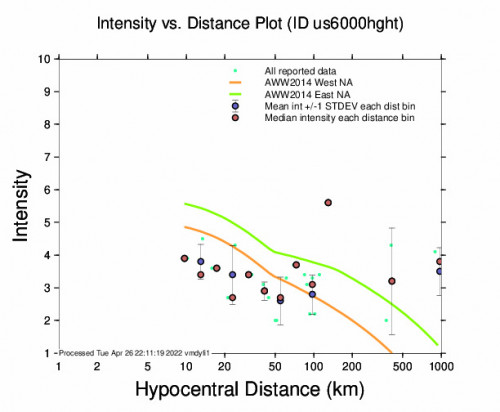
 Intensity vs Distance Plot
 Responses vs Time Plot
World Earthquake Watch
Below are the most recent earthquakes that have happened around the world. Visit our World Earthquake Watch page for a more complete list.
Fangale’ounga, Tonga 5.4 M Earthquake, Wednesday Apr. 24 2024, 6:53:32 PMKermadec Islands, New Zealand 5.2 M Earthquake, Wednesday Apr. 24 2024, 5:27:58 PMThe Loyalty Islands 5.5 M Earthquake, Wednesday Apr. 24 2024, 12:23:54 PMBoca Chica, Panama 5.5 M Earthquake, Tuesday Apr. 23 2024, 8:20:43 PMVan Horn, Texas 2.9 M Earthquake, Tuesday Apr. 23 2024, 5:58:02 PMRosarito, Mexico 2.9 M Earthquake, Tuesday Apr. 23 2024, 10:08:31 AMFalls City, Texas 2.6 M Earthquake, Tuesday Apr. 23 2024, 11:08:06 AMLajes Das Flores, Portugal 5.2 M Earthquake, Tuesday Apr. 23 2024, 3:40:03 PMPoint Mackenzie, Alaska 2.7 M Earthquake, Tuesday Apr. 23 2024, 5:34:30 AMNorthern Mid-atlantic Ridge 5.0 M Earthquake, Tuesday Apr. 23 2024, 1:05:38 PM


