Earthquake Details
Mawlaik, Myanmar 5.6m Earthquake, Friday Sep. 30 2022, 4:52:38 AM
Mawlaik, Myanmar Earthquake
The USGS has reported a 5.6 magnitude earthquake has struck 83 km SE of Mawlaik, Myanmar on Sep. 30 2022, 4:52:38 AM, at a depth of 165.131 km. There were no significant injuries or damage reported at this point, Friendly Forecast will update this report as events unfold.
Did you feel it?
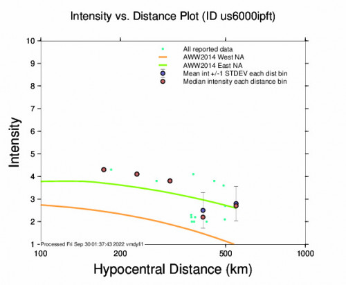
15 others have felt the Mawlaik, Myanmar earthquake and have since reported it. See below for the response locations and intensities.
 Community Internet Intensity Map
| Responses | Location | Shaking | Distance |
|---|---|---|---|
| 3 | Chattagam, Chattagam, Chāţţagām, Bangladesh | WEAK | 369 km |
| 1 | Uttar Dhurung, Uttar Dhurung, Chāţţagām, Bangladesh | WEAK | 363 km |
| 1 | Dacca, Dacca, Dhāka, Bangladesh | WEAK | 497 km |
| 1 | Ţungī, Ţungī, Gazipur, Bangladesh | LIGHT | 499 km |
| 1 | Baraghop, Baraghop, Koks Bāzār, Bangladesh | WEAK | 381 km |
| 1 | Fatekharkul, Fatekharkul, Koks Bāzār, Bangladesh | WEAK | 380 km |
| 1 | Itanagar, Itanagar, Arunachal Pradesh, India | LIGHT | 499 km |
| 1 | Diphu, Diphu, Assam, India | LIGHT | 380 km |
| 1 | Manipur, Manipur, Manipur, India | LIGHT | 272 km |
| 1 | Mawlai, Mawlai, Meghalaya, India | LIGHT | 450 km |
| 1 | Mandalay, Mandalay, Mandalay, Myanmar | LIGHT | 236 km |
| 1 | Pyinmana, Pyinmana, Mandalay, Myanmar | WEAK | 424 km |
| 1 | Mawlaik, Mawlaik, Sagaing, Myanmar | LIGHT | 184 km |
Did you feel the 5.6 Mawlaik, Myanmar earthquake? If you felt the quake you can report it here to the USGS.
Other Imagery and Data
 GEO Community Internet Intensity Map
 Intensity vs Distance Plot
 Responses vs Time Plot
 Macroseismic Intensity Map
 Peak Ground Acceleration Map
 Peak Ground Velocity Map
 0.3 Second Peak Spectral Acceleration Map
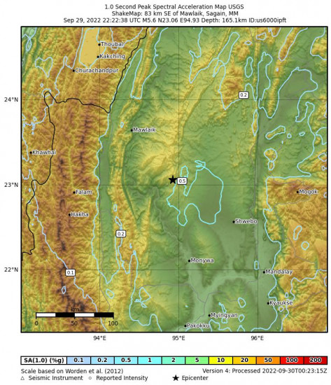
 1 Second Peak Spectral Acceleration Map
 3 Second Peak Spectral Acceleration Map
World Earthquake Watch
Below are the most recent earthquakes that have happened around the world. Visit our World Earthquake Watch page for a more complete list.
Hualien City, Taiwan 5.7 M Earthquake, Saturday Apr. 27 2024, 2:21:22 AMHoniara, Solomon Islands 5.1 M Earthquake, Saturday Apr. 27 2024, 3:25:43 AMNusa Dua, Indonesia 5.0 M Earthquake, Friday Apr. 26 2024, 9:43:19 PMSan Luis, Mexico 4.3 M Earthquake, Friday Apr. 26 2024, 4:17:21 AMPatea, New Zealand 4.3 M Earthquake, Friday Apr. 26 2024, 8:34:11 PMPāhala, Hawaii 2.8 M Earthquake, Thursday Apr. 25 2024, 8:48:37 PMSouth Sandwich Islands Region 5.0 M Earthquake, Friday Apr. 26 2024, 12:56:31 AMSan Antonio, Puerto Rico 3.6 M Earthquake, Thursday Apr. 25 2024, 3:39:27 PMHalibut Cove, Alaska 3.5 M Earthquake, Thursday Apr. 25 2024, 5:44:56 AMSmiths Ferry, Idaho 3.1 M Earthquake, Thursday Apr. 25 2024, 7:04:36 AM


